Loading
Search
▼ New Tech Plan Envisions 3-D Maps For Driverless Cars
- Category:Other
The Yomiuri Shimbun
Three-dimensional maps, a feature essential for self-driving vehicles, could be made from big data that the government plans to compile as part of its initiative to create a “super-smart society,” The Yomiuri Shimbun has learned.
The goals were contained in a rough draft of the Comprehensive Strategy on Science, Technology and Innovation 2016 that the Cabinet plans to approve as soon as the end of May.
According to the draft, the government aims to establish databases encompassing five different fields before the 2020 Tokyo Olympics and Paralympics are held. It plans to give its economic growth strategy a shot in the arm by using massive amounts of big data to nurture new industries.
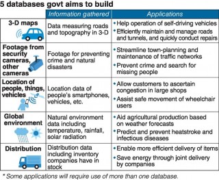
The draft stresses the necessity of jointly collating and sharing information that is currently possessed separately by the government, companies and individuals. It sets a goal of establishing five databases that industry, government and academia can use by 2020, setting them up in the fields of 3-D maps; footage from security and other cameras; pinpointing the locations of people, things and vehicles; the global environment; and distribution.
Of these five, the government is giving top priority to establishing the database for 3-D maps because it believes this is most likely to be translated from the drawing board to reality. The database would hold data including 3-D measurements of roads and topography, and collect information about damage to roads and tunnels detected by sensors on self-driving vehicles.
As well as being essential for the operation of driverless vehicles, this information will be used to quickly grasp which sections of a tunnel need repairs.
The footage from security and other cameras will be applied in facial automatic-recognition technologies. It is expected to be used to help search for elderly dementia sufferers who have gone missing, and to assist in criminal investigations and steps to combat terrorism.
The government’s Fifth Science and Technology Plan, a five-year blueprint for the nation’s science and technology policies that started in fiscal 2016, sets the goal of creating a super-smart society.
This year’s comprehensive strategy spells out some concrete efforts toward achieving that objective.
The government is pushing ahead with what has been dubbed the “fourth industrial revolution,” the fourth monumental change of its kind behind the advent of the steam engine, electricity and then the computer. The fourth edition centers on using the Internet and artificial intelligence.
“Databases will be an essential element in this,” a government source said.
The plan is to get a jump on the rest of the world in realizing a super-smart society to boost the nation’s competitiveness and promote economic growth.
- April 18, 2016
- Comment (0)
- Trackback(0)


