Loading
Search
▼ Typhoon Hagibis May Head For Japan Over Weekend
- Category:Other
Japanese weather officials warn that a typhoon may approach wide areas from western to northern Japan over the weekend.
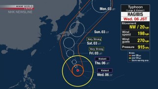
The Meteorological Agency says the large and violent Typhoon Hagibis is heading northwest near the Mariana Islands as of Wednesday morning, Japan time.
The agency says the typhoon could come very close to western and eastern Japan before moving toward northern Japan on Saturday through Sunday.
Winds will begin to grow strong in the Ogasawara Islands on Wednesday, and seas will become very rough from Thursday.
Rough sea conditions are forecast also for the Daitojima region in Okinawa Prefecture and the Amami region in Kagoshima Prefecture from Thursday. Waves will be high along the Pacific coast of eastern and western Japan from Friday.
The agency says Hagibis developed rapidly in 24 hours into what US weather officials call a super-typhoon. In the US, a typhoon packing winds up to around 210 kilometers per hour is categorized as a super-typhoon.
The agency says Hagibis's central atmospheric pressure decreased by 77 hectopascals from Sunday to Monday.
Professor Kazuhisa Tsuboki of Nagoya University says it is rare for a typhoon to develop so sharply within a day. A decrease of around 40 hectopascals within 24 hours is said to be a rapid development, a phenomenon typical of powerful typhoons.
He attributes the rapid development to high sea water temperatures in areas the typhoon has travelled through. He warns that Hagibis may maintain its power as it approaches Japan, because seawater around the county is warmer than average.
- October 9, 2019
- Comment (0)
- Trackback(0)


