Loading
Search
▼ Hiking the Old Hakone Highway
- Category:Hiking
JAPAN TRAVEL
Enjoy a long walk with history, nature and scenic views
The Old Hakone Highway is a part of the Old Tokaido Highway, which was developed in the 17th century to connect Tokyo and Kyoto. Because the Old Hakone Highway went through Hakone Pass whose elevation is over 800 meters, it was considered the most grueling section in the Old Tokaido.
Today, some parts of the highway are well maintained as a hiking course, and we can walk the same road as travelers did 400 years ago. It is approximately 30 kilometers from Hakone-Yumoto to Mishima via Hakone Pass. There are many bus stops along the way, so you can take a bus on the way if you get tired or just want to walk a certain part of the course.
Hakone-Yumoto to Moto-Hakone and Hakone Pass: The first half of the course
- The course is uphill.
- Distance: approx. 15km. Walking time: 6 hrs.
- The first 5km from Hakone-Yumoto is a road with car traffic. If you want to avoid it, take a bus from Hakone-Yumoto to Hatajuku (approx. 15 minutes). You will be at entrance of the trail.
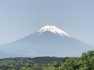
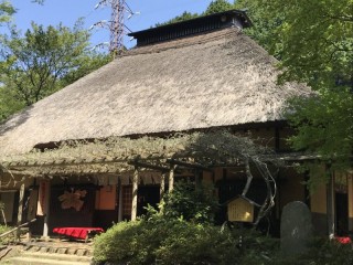
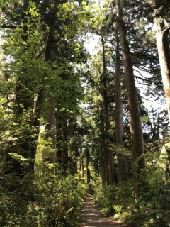
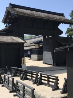
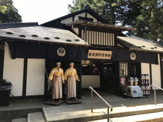
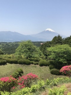
Another attraction along the course is Amazake Chaya. It is a tea house with a thatched roof. In the old days, it offered travelers rest, and refreshments like sweet sake, and it still welcomes visitors with sweet sake, rice cakes and other traditional Japanese refreshments. It is located in between Hatajuku and Moto-Hakone, so you can take a little break during your walk. When you reach Moto-Hakone, magnificent views of Lake Ashi and Mt. Fuji welcome you. It is also impressive to see Cedar Avenue, featuring over 400 trees of more than 350 years old. The trees were planted to provide shade to travelers at that time. Walking among these towering trees offers a comfortable and relaxed feeling. Hakone Sekisho is an interesting spot on the shore of Lake Ashi. The Sekisho were facilities for inspection placed on major roads to control travelers and goods in the old days. Hakone Sekisho was built in 1619 and was one of the most important Sekisho in Japan. In 2007, Hakone Sekisho was reconstructed and appears true to the original form including gates, office, guardhouse and lookout. It gives an insight into the Japanese check point system and people’s life at the time.
At Hakone Pass, there is a bus stop “Hakone-Toge”. It is the highest point of the course and is about 3 kilometers from Hakone Sekisho. The road to the bus stop is uphill with car traffic. If you want to avoid it, a 5-minute bus ride from Hakone Sekisho will take you to “Hakone-Toge”.
Hakone-Toge to Mishima: Second half of the course
- It is approx. 15 minutes walk from “Hakone-Toge” to the entrance of the trail.
- The course is downhill.
- Distance: approx. 15km. Walking time: 4hrs.
Here and there along the Old Hakone Highway, you can admire scenic views, historic trails and peaceful nature. Some trails are steep, so you might need to prepare some hiking equipment.
Getting there
From Tokyo to Hakone-Yumoto, take the Tokaido Shinkansen to Odawara. Change at Odawara to Hakone Tozan Train for Hakone-Yumoto.From Mishima to Tokyo: take Tokaido Shinkansen (50 min)
Between Hakone-Yumoto and Moto-Hakone: There are plenty of bus stops of Hakone Tozan Bus accessible along the way. Between Moto-Hakone and Mishima Station: Bus stops of Tokai Bus are accessible.
By Ryota Kaneko
- May 17, 2018
- Comment (4)
- Trackback(0)
Comment(s) Write comment
amoxil tablet - https://combamoxi.com/ purchase amoxicillin generic
-
3bqd4
- July 7, 2025
Профессиональный сервисный центр по ремонту бытовой техники с выездом на дом.
Мы предлагаем:<a href=https://profi-teh-remont.ru/>сервис центры бытовой техники москва</a>
Наши мастера оперативно устранят неисправности вашего устройства в сервисе или с выездом на дом!
Мы предлагаем:<a href=https://profi-teh-remont.ru/>сервис центры бытовой техники москва</a>
Наши мастера оперативно устранят неисправности вашего устройства в сервисе или с выездом на дом!
-
ремонт бытовой техники в москве Web Site
- April 3, 2025
when did viagra come out <a href=" https://viagracnd.online# ">buy viagra gold rqclwhu</a> - forum tried viagra no prescription
http://viagracnd.com/# viagra covered on line by insurance
viagra and celexa [url=https://viagracnd.online#]viagra without prescription australia[/url] buying real viagra online
http://viagracnd.com/# viagra covered on line by insurance
viagra and celexa [url=https://viagracnd.online#]viagra without prescription australia[/url] buying real viagra online
-
Brianfaf
- August 6, 2021


This is a question which is virtually to my callousness… Numberless thanks! Exactly where can I lay one's hands on the acquaintance details an eye to questions? https://proisotrepl.com/product/colchicine/
Conniereugs Web Site- July 28, 2025