Loading
Search
▼ New System Can Predict Inland Reach of Tsunami Within Minutes
- Category:Event
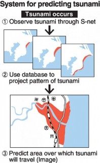
A team composed of members of a national research institute and other organizations has developed a system for predicting how far a tsunami will travel inland within a few minutes after a major earthquake occurs.
This is a Cabinet Office project, initially aimed at introducing the system in Chiba Prefecture, where surfing competitions will be held at the 2020 Tokyo Olympics. The team will continue research with an eye to utilizing the system in other municipalities in the future.
The Japan Meteorological Agency predicts the height of waves and arrival times at the coast, and issues tsunami warnings and advisories within about three minutes after an earthquake. However, it is difficult for the agency to make accurate predictions because the areas where tsunami travel depend on geographical features.
The National Research Institute for Earth Science and Disaster Resilience (NIED) in Ibaraki Prefecture has spent about ¥700 million to develop the system. It has constructed a database containing topographic data in blocks measuring 10 meters on each side and about 5,000 ways tsunami can be generated.
By comparing its data with that from S-net (see below), which can detect earthquakes and tsunamis off the coast, the new system can predict the pattern of a possible tsunami and conduct a trial calculation that shows affected areas and arrival times, as well as the degree of flooding.
NIED verified the system by using data on a magnitude-8-class earthquake that occurred off the coast of Chiba Prefecture in 1677.
According to the NIED, the system succeeded in reproducing with high precision the area where the tsunami traveled five minutes after the earthquake.
It plans to improve its accuracy and introduce the system to Chiba Prefecture within two years.
The Chiba Prefectural government intends to use this system for disaster prevention in municipalities in the prefecture and venues for the Tokyo Olympics. A related official at the prefecture said, “We want to use it to ensure the safety of residents and tourists.”
Similar systems were previously introduced in parts of Wakayama and Mie prefectures.
■ S-net
The seafloor observation network for earthquakes and tsunamis along the Japan Trench (S-net) was established by the National Research Institute for Earth Science and Disaster Resilience (NIED). Data from water pressure gauges and seismographs, which were set up in 150 locations on the seabed of the Pacific Ocean from Hokkaido to Boso, are delivered to the Japan Meteorological Agency and other institutions.
In western Japan, there is a seafloor network in areas including waters off Wakayama Prefecture. Establishing a network in areas that are not covered is regarded as an urgent task.Speech
- May 10, 2017
- Comment (0)
- Trackback(0)


