
Loading

Search
▼ Japan In Focus / Secrets Of Kyoto / Kyoto’s Go-Style Grid Design Adds To Its Elegance
- Category:Other
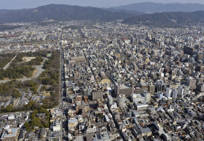
KYOTO — The central part of Kyoto, widely known as Rakuchu, is often likened to the grid pattern seen in Go, a traditional board game in East Asia, in which players use a square board with grid lines. This grid pattern is what is used to describe the city’s layout. For many readers in the West, a checkerboard would be the more familiar equivalent to a Go board.
In other words, the streets of Rakuchu are precisely arranged with regularity in both vertical and horizontal directions.
I find the metaphor of comparing the city layout to a Go grid elegant and very much Kyoto-esque. In Europe, such a city design is known as a hippodamian plan, named after Hippodamus, a city planner from around the fifth century B.C.
Urban planning to divide the land into plots with straight streets was first introduced in ancient Greek colonies. The concept was then adopted in a number of cities around the world, before wielding influence on Manhattan’s redevelopment project in the 19th century.
There were also cities in East Asia designed with a quadrangular grid pattern. According to “Kaogong Ji” — the artificers’ record believed to have been compiled during China’s Spring and Autumn and Warring States periods (770 B.C.-221 B.C.) — an ideal imperial palace should be designed in a quadrangular shape, and main roads should intersect crosswise.
A typical example of a city ideally planned with a grid pattern is Changan, present-day Xian, which served as a capital to ancient Chinese dynasties. Its peak population exceeded 1 million at one point.
With the concept of China’s urban planning brought to Japan, the quadrangle-shaped city of Fujiwarakyo was established in today’s Nara Prefecture in 694. It was followed by the construction of the ancient capital Heijokyo. Built north of Fujiwarakyo, the shape of Heijokyo was an irregular rectangle shape that slightly extended north to south.
Heiankyo, the predecessor of Kyoto, was established in 794. The city was also designed as a long rectangle, extensively stretching from north to south, unlike the Chinese style. Kyoto’s Rakuchu district mentioned earlier basically refers to the area previously defined as Heiankyo.
The population of Heiankyo is estimated to have been about 175,000 in around 1000 when author and dweller of the city Murasaki Shikibu wrote the Japanese literary landmark “The Tale of Genji.” London and Paris around that time were still small cities with populations of roughly 20,000 each. Needless to say, New York did not yet exist.
How about Tokyo, Japan’s capital city after Kyoto? A look at the map shows several ring roads spreading in and around the city, just like in Paris and London, which were both later transformed to metropolises. However, those of Tokyo were built in the 20th century.
Formerly known as Edo, the city developed as the center of politics following the 1603 establishment of a shogunate government and quickly grew into a city with a population of 1 million. As the urban area was expanding rapidly, Tokyo’s road traffic network was gradually spreading into what looked like a parquetry floor with an inconsistent pattern, apart from the front area of Edo Castle’s Otemon gate.
The population of Kyoto also started growing after the Sengoku warring states period (from the late 15th century to the late 16th century). Unlike Edo, which was on the Kanto Plain, Kyoto is located in a basin. As a result, the city experienced modifications in its city layout in an effort to house an increasing number of dwellers, according to Akihiro Kinda, director of the Kyoto Institute, Library and Archives. The modifications include building new roads designed to run vertically and horizontally through each plot on the Go grid pattern.
In the city of Heiankyo, aristocrats would use a whole plot, or half of it, to build a residence for themselves. However, many of these large houses burned down during the Onin War (1467-77). After that, it became more common to erect smaller houses along streets, leaving each plot’s central part vacant. This layout prompted the construction of a new road running through each plot, cutting it into two, resulting in more houses to be built along new streets, according to Kinda, who explained to me the history of Kyoto’s city planning using old maps.
A half size of the square-shaped plot of land was described as the shape of tanzaku, a long narrow strip of thick paper used to write waka, haiku and other short poems. I must say I also find the name of this expression, which has a touch of classic literature, very much Kyoto-esque.
***
This column, which appears once a month, is about various aspects of the culture of Kyoto.
Mori was born and raised in Kyoto. He has 30 years of experience in reporting about Kyoto culture. He has extensively covered scholars of the New Kyoto school, the heads oftea ceremony and flower arrangement schools, as well as maiko in the Gion area of the city.
- February 27, 2019
- Comment (0)
- Trackback(0)