
Loading

Search
▼ Quakes Disrupted Flows of Kyushu Groundwater
- Category:Other
The Yomiuri Shimbun
KUMAMOTO — Abnormalities have been observed in Kumamoto Prefecture’s abundant groundwater sources, apparently due to a series of earthquakes that hit the prefecture and its surrounding area.
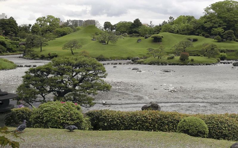
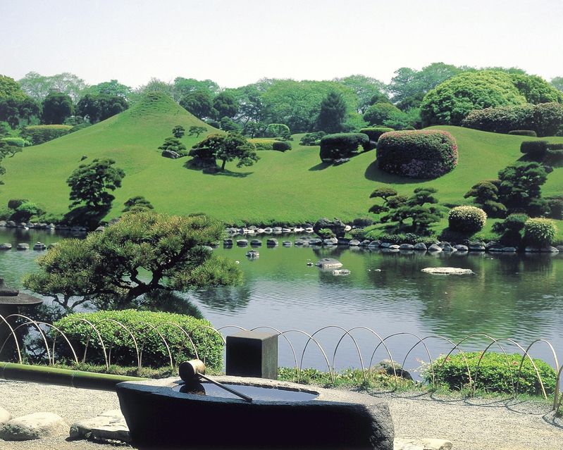
Water in the spring-fed pond of Suizenji Jojuen park, commonly called Suizenji Park, has almost disappeared. The park in Chuo Ward, Kumamoto, is designated by the government as a place of scenic beauty and a historic site.
“The flow of groundwater could have changed due to the earthquakes,” an expert said.
Toru Iwata, 68, representative priest of Izumi Shrine, which manages the park, said he found that about 70 percent to 80 percent of the water in the one-hectare pond was gone on the morning of April 15, the day after a major tremor that is now recognized as a foreshock to the main quake. The depth of the water had been up to 50 centimeters before the series of quakes began.
The pond was refilled as groundwater was pumped into it, but about 70 percent to 80 percent of the water disappeared again after the main shock on April 16.
The Suizenji-Lake Ezu Springs that surround the park were designated in 2008 by the Environment Ministry as part of the Selected 100 Exquisite and Well Conserved Waters in the Heisei era. Suizenji Park has been a popular tourist site attracting about 400,000 visitors annually.
KUMAMOTO — Abnormalities have been observed in Kumamoto Prefecture’s abundant groundwater sources, apparently due to a series of earthquakes that hit the prefecture and its surrounding area.
Water in the spring-fed pond of Suizenji Jojuen park, commonly called Suizenji Park, has almost disappeared. The park in Chuo Ward, Kumamoto, is designated by the government as a place of scenic beauty and a historic site.
“The flow of groundwater could have changed due to the earthquakes,” an expert said.
Toru Iwata, 68, representative priest of Izumi Shrine, which manages the park, said he found that about 70 percent to 80 percent of the water in the one-hectare pond was gone on the morning of April 15, the day after a major tremor that is now recognized as a foreshock to the main quake. The depth of the water had been up to 50 centimeters before the series of quakes began.
The pond was refilled as groundwater was pumped into it, but about 70 percent to 80 percent of the water disappeared again after the main shock on April 16.
The Suizenji-Lake Ezu Springs that surround the park were designated in 2008 by the Environment Ministry as part of the Selected 100 Exquisite and Well Conserved Waters in the Heisei era. Suizenji Park has been a popular tourist site attracting about 400,000 visitors annually.
“All we can do is to wait for the groundwater to recover,” Iwata said.
According to a Kumamoto city government survey, the depth of groundwater around the park became 20 centimeters lower. Meanwhile, Tokai University Prof. Tsutomu Ichikawa of the Liberal Arts Education Center at Kumamoto Campus, who specializes in groundwater, said the amount of springwater in nearby Lake Ezu seemed to have increased.
Around Aso Shrine in Aso in the prefecture, several springs reportedly either ran dry or gushed aggressively after the main shock.
Kumamoto Prefecture and its surrounding area are located on a plateau of volcanic sediment created by eruptions of Mt. Aso, and have layers of earth rich in groundwater. As the volcanic sediment is highly porous, it is easily penetrated by rainwater. Natural reserves of groundwater accumulate in shallow and deep layers that are separated by a clay stratum called the Futa layer.
Ichikawa suggested two hypotheses for the abnormal changes in groundwater.
In one hypothesis, the groundwater that had flowed from east to west moved south when the ground tilted to the south. This change led to a decrease in the amount of groundwater at some spots. In fact, the surface of the ground sank about 15 centimeters in the town of Kashima, which is south of Suizenji Jojuen park.
The other hypothesis suggests that the groundwater in the shallow layer flowed into the deeper layer due to the Futa clay stratum breaking or other reasons. However, as the stratum around the park measures as thick as about 10 meters, the professor thinks this theory is less likely.
- April 29, 2016
- Comment (0)
- Trackback(0)