
Loading

Search
▼ Tropical Storm South Of Japan Bringing Heavy Rain Along Pacific
- Category:Nature
Japanese weather officials say a tropical depression over waters east of Amami-Oshima Island in southwestern Japan developed into a tropical storm as of 3 a.m. on Thursday, local time.
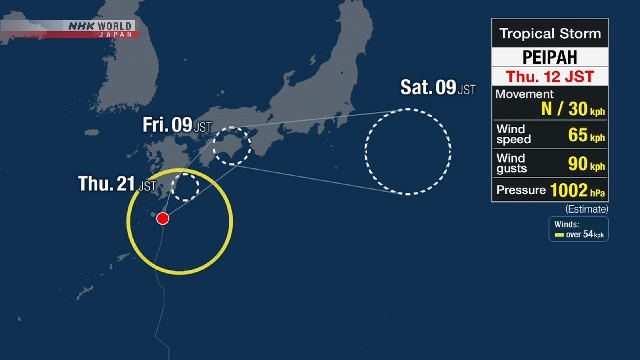
Tropical Storm Peipah is expected to approach western Japan. But extreme localized downpours are already pounding southern Kyushu, prompting risks of mudslides and floods in low-lying areas.
Peipah has a central atmospheric pressure of 1,002 hectopascals and is packing winds of over 64 kilometers per hour near its center, with gusts of up to 90 kilometers per hour. It is moving north at a speed of 30 kilometers an hour.
As warm and damp air from the south is flowing in, atmospheric conditions have destabilized considerably, mainly along the Pacific side of western Japan, and rain clouds have developed above southern Kyushu.
Tsuno Town in Miyazaki Prefecture was pelted by 71 millimeters of rain in the hour until 3:30 a.m. on Thursday.
During the hour ending at 4 a.m., Kunitomi Town, also in Miyazaki Prefecture, observed 38 millimeters of rain and the city of Miyazaki had 34 millimeters.
The tropical storm is expected to take a northerly course and approach western Japan, including Kyushu, before heading east toward eastern Japan by Friday.
Heavy rain is likely along the Pacific in both western and eastern Japan. Extreme localized downpours of more than 50 millimeters an hour may be in store.
As damp air will continue to flow in, rainfall may accumulate.
Weather officials are warning of mudslides and floods in low-lying areas, swollen rivers, river overflows, gusts and high waves, as well as lightning and freak winds, including tornadoes.
- September 5, 2025
- Comment (0)
- Trackback(0)