
Loading

Search
▼ Japan: Krosa To Be The Third Tropical Cyclone To Hit The Country In As Many Weeks
- Category:Other
Japan is bracing for significant impacts from Severe Tropical Storm Krosa, as the storm churns over the west Pacific to the south of the country.
As Japan recovers from the impacts of Typhoon Francisco and Tropical Storm Nari, Krosa is expected to bring impacts ranging from flooding to mudslides and damaging winds as early as Wednesday.
Krosa would be the third tropical cyclone to make landfall across mainland Japan in as many weeks as active conditions across the western Pacific continue.
Despite weakening into a tropical storm, Krosa is forecast to once again become a typhoon prior to making landfall in southern Japan as early as Thursday.
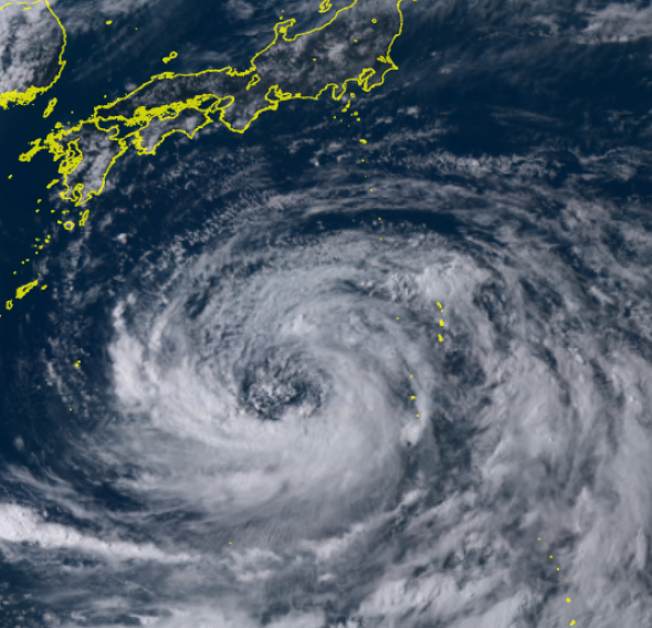
Tropical Storm Krosa on Monday afternoon, local time, located south of Japan. (Japanese Meteorological Agency/Himawari 8)
While Krosa is still located well to the southeast of Japan, it has far-reaching impacts with bands of rain affecting islands from Ogasawara, Japan, to the Northern Mariana Islands.
The large size of Krosa will also allow rain bands to affect the northern Ryukyu Islands and southern Japan by the end of the day on Tuesday despite the center of the storm still being well offshore.
The most likely areas for significant impacts are expected to be across southern Japan, including Shikoku, Kyushu and western Honshu.
Conditions will worsen across southern Japan from Wednesday into Thursday as Krosa approaches Kyushu and Shikoku from the south.
Impacts will range from damaging wind gusts near the point of landfall to flooding rainfall, mudslides and storm surge flooding along south-facing coasts.
Weakening is expected as Krosa crosses southern Japan from Thursday into Thursday night.
Damaging winds will be a concern across Kyushu, Shikoku and southwest Honshu where wind gusts of 65-95 km/h (40-60 mph) will be common.
Locations near and just east of where Krosa makes landfall will be at risk for wind gusts up to 130 km/h (80 mph).
Heavy rainfall will also raise the risk for flooding and mudslides across southern Japan from Wednesday afternoon into Friday morning.
An AccuWeather Local StormMax™ of 500 mm (20 inches) is possible in the hardest hit locations of southern Japan. Areas at greatest risk for this magnitude of rainfall will be across Kyushu and Shikoku.
Residents in cities from Nobeoka to Kochi and Osaka should continue to monitor this storm and have a plan in place should evacuations be ordered.
As Japan recovers from the impacts of Typhoon Francisco and Tropical Storm Nari, Krosa is expected to bring impacts ranging from flooding to mudslides and damaging winds as early as Wednesday.
Krosa would be the third tropical cyclone to make landfall across mainland Japan in as many weeks as active conditions across the western Pacific continue.
Despite weakening into a tropical storm, Krosa is forecast to once again become a typhoon prior to making landfall in southern Japan as early as Thursday.
Tropical Storm Krosa on Monday afternoon, local time, located south of Japan. (Japanese Meteorological Agency/Himawari 8)
While Krosa is still located well to the southeast of Japan, it has far-reaching impacts with bands of rain affecting islands from Ogasawara, Japan, to the Northern Mariana Islands.
The large size of Krosa will also allow rain bands to affect the northern Ryukyu Islands and southern Japan by the end of the day on Tuesday despite the center of the storm still being well offshore.
The most likely areas for significant impacts are expected to be across southern Japan, including Shikoku, Kyushu and western Honshu.
Conditions will worsen across southern Japan from Wednesday into Thursday as Krosa approaches Kyushu and Shikoku from the south.
Impacts will range from damaging wind gusts near the point of landfall to flooding rainfall, mudslides and storm surge flooding along south-facing coasts.
Weakening is expected as Krosa crosses southern Japan from Thursday into Thursday night.
Damaging winds will be a concern across Kyushu, Shikoku and southwest Honshu where wind gusts of 65-95 km/h (40-60 mph) will be common.
Locations near and just east of where Krosa makes landfall will be at risk for wind gusts up to 130 km/h (80 mph).
Heavy rainfall will also raise the risk for flooding and mudslides across southern Japan from Wednesday afternoon into Friday morning.
An AccuWeather Local StormMax™ of 500 mm (20 inches) is possible in the hardest hit locations of southern Japan. Areas at greatest risk for this magnitude of rainfall will be across Kyushu and Shikoku.
Residents in cities from Nobeoka to Kochi and Osaka should continue to monitor this storm and have a plan in place should evacuations be ordered.
- August 12, 2019
- Comment (0)
- Trackback(0)